Tropical depression forecast to strengthen into storm, Hai Phong warns of heavy rain
A tropical depression over the East Sea is likely to strengthen into a tropical storm on July 3, directly affecting the northern waters of the Gulf of Tonkin, according to the Hai Phong Hydro-Meteorological Station.
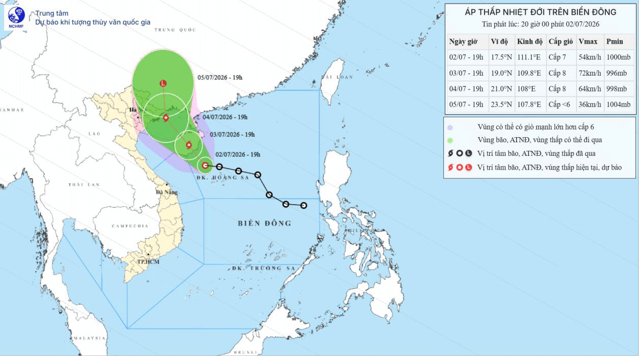
The station said that by 7 p.m. on July 3, the tropical depression is forecast to move northwest at around 10 kph and is likely to strengthen into a tropical storm, affecting the western waters of the northern East Sea, including the Hoang Sa Special Zone.
By 7 p.m. on July 4, the storm is expected to continue moving northwest at 10–15 kph, maintaining intensity at force 8 with gusts up to force 10. Its area of influence is forecast to expand to the northwestern waters of the northern East Sea and the northern Gulf of Tonkin, including the Bach Long Vi, Van Don, Co To and Cat Hai Special Zones, as well as Hon Dau Island.
During the following 48 to 72 hours, the storm is forecast to move north-northwest at 10–15 kph before gradually weakening into a tropical depression.
Under the influence of the tropical depression, and later the storm, the western waters of the northern East Sea, including the Hoang Sa Special Zone, are forecast to experience winds of force 6–7, strengthening to force 8–9. Waves are expected to reach 2–4 meters, rising to 3–5 meters near the storm's center, with rough seas.
From the night of July 3, the northern Gulf of Tonkin, including the Bach Long Vi and Cat Hai Special Zones, the waters off Cat Ba and Lan Ha Bay, is forecast to experience gradually strengthening winds of force 6–7, increasing to force 8 near the storm's center with gusts of force 9–10. Waves are expected to reach 2–4 meters, with rough seas.
From the morning of July 4, coastal wards of Hai An, Dong Hai, Nam Trieu, Do Son, Nam Do Son and Duong Kinh, along with the communes of Chan Hung, Hung Thang and Kien Hai, may experience winds of force 5, occasionally reaching force 6 with gusts up to force 7.
The meteorological authority warned that all vessels, anchorages, aquaculture areas, sea dikes and embankments, and offshore activities in affected areas face a high risk from thunderstorms, tornadoes, strong winds and high waves. Strong winds could uproot trees, damage homes, transport infrastructure and other facilities, posing a threat to public safety.
From the night of July 3 through July 5, Hai Phong is forecast to experience moderate to heavy rain, with isolated very heavy downpours accompanied by thunderstorms. During thunderstorms, there is a risk of tornadoes, lightning and strong wind gusts.
Hai Phong News