Hai Phong forecast to experience thunderstorms
It is forecast that from now until the next three hours, convective clouds may move in and cause thunderstorms in several wards and communes of Hai Phong.
Radar images of the Hai Phong Hydrometeorological Station show convective clouds developing over Hai An ward of Hai Phong city. In addition, convective clouds from Quang Ninh and over the Gulf of Tonkin are also moving toward Hai Phong.
It is forecast that from now until the next three hours, the convective clouds may move in and cause thunderstorms in the above-mentioned areas and nearby wards and communes, including Kien An, Hung Dao, Duong Kinh, An Hung, An Khanh, An Quang, An Truong, An Lao, Kien Thuy, Kien Minh, Kien Hai, Kien Hung, Nghi Duong, Quyet Thang, Tien Lang, Tan Minh, Tien Minh, Chan Hung, Hung Thang, Vinh Bao, Nguyen Binh Khiem, Vinh Am, Vinh Hai, Vinh Hoa, Vinh Thinh, Vinh Thuan, Do Son and adjacent wards and communes.
During thunderstorms, caution is advised against whirlwinds, lightning, and strong gusts of wind that may break trees, damage houses, transportation works, and infrastructure, posing danger to human life as well as to aquaculture and fishing activities at sea.
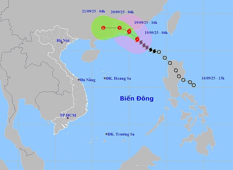
Due to the influence of circulation from storm No. 8 (internationally called Mitag), today (September 19), the eastern part of the north East Sea, the central and southern East Sea (including Truong Sa waters), the Gulf of Tonkin, the waters from southern Quang Tri to Ca Mau, Ca Mau to Kien Giang, and the Gulf of Thailand will experience scattered showers and thunderstorms.
In particular, the northern part of the East Sea will have strong winds of level 6 – 7, gusting to level 9; areas near the storm’s center will experience winds of level 8 – 9, gusting to level 11, with waves 3 – 5 m high and very rough seas.
Vessels operating in dangerous areas are at risk of being affected by strong winds, high waves, and whirlwinds.
It is forecast that from early morning to the afternoon of September 19, the coastal areas of the North will have scattered showers and thunderstorms, with common rainfall of 10 – 30 mm, and some places over 60 mm.
Localities, especially coastal areas, need to closely monitor the storm’s developments, prepare response plans, and ensure the safety of people and production activities.
Hai Phong News